Project BG 161 PO 004-4.0.01-0003
Implementation of River Information System in the Bulgarian stretch of Danube River - BULRIS
Financed by the European Regional Development Fund under Operational Programme on Transport 2007 – 2013, Priority Axes 4 Improvement of the maritime and inland - waterway navigation”
Total project cost: 37 427 697,90 BGN.
Financing by European Regional Development Fund: 26 608 561,43 BGN.
National co-financing: 4 695 628,49 BGN.
Own financing: 6 123 597, 98 BGN.
Beneficiary: Bulgarian Ports Infrastructure Company
BULRIS is a complex large-scale project that involves design and construction activities and procurement of hardware and software for communication, radio relay, and radar systems and a system for monitoring and visualisation of ship traffic. Accomplishment of the project “Implementation of River Information System in the Bulgarian stretch of the Danube River – BULRIS” is separated in two phase:
RIS Centre Ruse First Phase (2007 – 2013) – Establishing of RIS.
Second phase (2012 – 2015) Implementation of River Information System in the Bulgarian stretch of the Danube River – BULRIS – expansion the scope of the system and the services, divided into three lots:
Lot 1: Construction of RIS centre Ruse and construction supervision;
Lot 2: Expansion the scope of the system and the services;
Lot 3: Implementing a system for monitoring and recording the condition of the riverbed.
Main Objective of the Project
Harmonization of information services in support to traffic and transport management in inland waterways navigation in conformity with Directive 2005/44/EU. As Member State of the European Union, Bulgaria is responsible for the building of a river information system as part of the trans-European network, in compliance with the technical guidelines for the design, implementation and operational use of the river information services (RIS) in order to ensure efficient and safe navigation on the inland waterways.
Specific Project objectives are:
- Development of telecommunication infrastructure of the river information system in the Bulgarian stretch of the Danube River – BULRIS, to ensure full and continuous transmission of all data along the entire Bulgarian stretch without lack of coverage, with common point the building of BULRIS Centre Ruse;
- Establishing conditions to ensure interaction with the information systems serving the other transport modes;
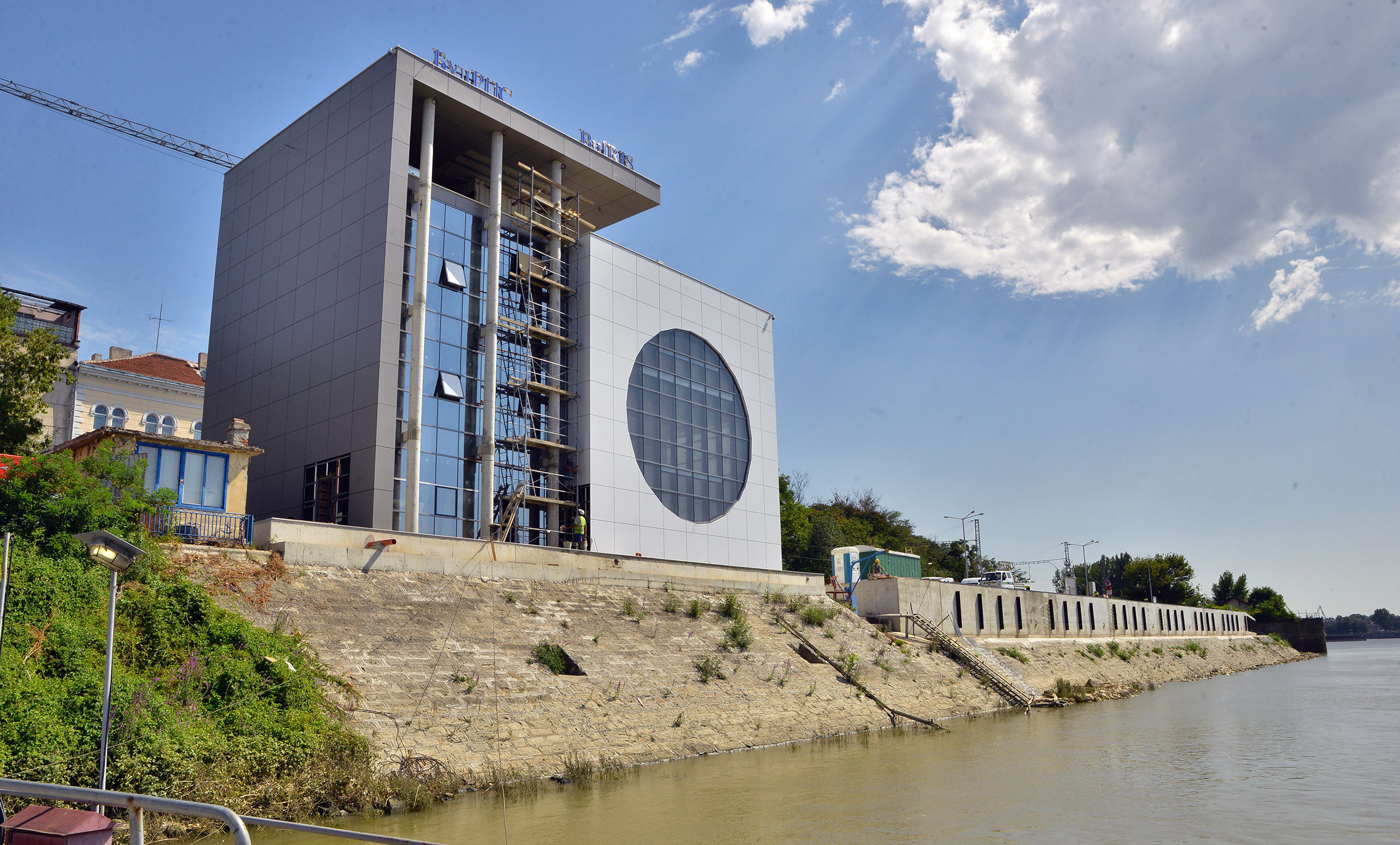
- Construction of a modern building RIS centre in Bulgaria;
Provision of river information services in real time is essential to reduce the risks for vessels pass through critical sections on the Danube and thus – to increase the level of safety for shipping. The system creates conditions also for increasing the efficiency of transport on inland waterways. BULRIS is an important element of the complex of measures for control and prevention of pollution in Europe’s largest river. Deployment of information technologies in management of logistics and transport processes is a key element of modern transport.
River information services (RIS) are navigation systems, serving ships and institutions responsible for traffic management, waterway maintenance, safety of navigation, environmental protection and others. The currently traditional track record communication between the ships and various shore offices serving shipping was implemented through radio, telephony, visual surveillance and other traditional methods. RIS is an environment where modern electronic navigation can be implemented, which is a practice in maritime transport. The systems for vessel traffic monitoring that are integrated into BULRIS provide real-time information for the coastal services and the data necessary for safe navigation: AIS data, radar images and video surveillance with optional for thermal image.
- actual data on the fairway – internal electronic navigation maps, Internet applications for notices to skippers, route radar systems, voyage planning;
- information on actual legislation – mode of navigation in the territory of each country;
- waterway hazards/distress signals;
- information on transport and logistics arrival date, type of load, free volumes of the vessel, etc.;
- traffic control – ensures the safety and security of shipping. Provides electronic ship reporting, monitoring and tracking of ships, automatic identification (АIS).

Following the amendments to the Law on Maritime Spaces, Inland Waterways and Ports of the Republic of Bulgaria, the functions of information support of shipping are assigned to Bulgarian Ports Infrastructure Company (BPI Co.).
The Regulation on the provision of river information services on inland waterways of the Republic of Bulgaria (amended in 2014) in the Bulgarian legislation transposing the provisions of Directive 2005/44/ЕC of the European Parliament and of the Council of 7 September 2005 to harmonize the river information services (RIS) on inland waterways in the community.
Function and options of the main subsystems
BULRIS combines functionalities and data, collected by several subsystems:
- Radio-relay transmitting network (MCL)
- Wide Area Network (WAN)
- Radio-telephone subsystem (VHF/ATIS)
- Automatic Identification System (AIS)
- Telephone subsystem (VoIP)
- Security subsystem
- Visualization of shipping traffic (VTT)
- Notices to skippers (NtS)
- Electronic reports (ERI)
- Radar subsystem
- Video surveillance on specific sections by thermo cameras
- Crisis situations system with 3D modelling
- Wi-Fi subsystem
Radio-Relay transmitting network
Radio-relay transmitting network (MCL) is built of 13 radio-relay lines with total length of 396 km. MCL provides data transmitting from eight base stations to the RIS Centre.
Wide Area Network
This is communication infrastructure, including routers, switches and other auxiliary devices serving for data transmission, increasing flexibility, adding VPN connectivity and optimization of connectivity of RIS Centre Ruse and RIS centre Varna and the sites of the system. Wide Area Network is one of the most important subsystems of the project – it allows remote control and is built in configuration providing opportunities for increasing productivity.
Radio-telephone subsystem
Purpose of this system is to provide continuous radiotelephone coverage in the Bulgarian stretch of the Danube River. It consists of eight base stations. In each of them there are three VHF radiotelephones that are associated with the wide area network and can be controlled remotely by the RIS centre.
Automatic Identification System
The Automatic Identification System (AIS) also works VHF frequencies but unlike the radiotelephone subsystem use digital channels. Therefore, all base stations for radiotelephone subsystems are used also for AIS base stations. The main functions of AIS subsystem are to receive information from all ships that are in its range (Bulgarian stretch of the Danube River). By the relay and wide area network, the data from ships’ AIS stations are transmitted to RIS Centre where are recorded in a database. By specialized software database information is visualized on vector maps.
Telephone subsystem
This a technology that allows transmission of voice (telephony) thanks to the infrastructure of the Internet (VoIP). The Telephone subsystem consists of 30 VoIP telephones, 13 are located in all remote sites along the Danube – 8 base stations and 5 repeater points, 11 telephones are in the RIS center in Ruse and 6 in the reserve centre in Varna.
Security subsystem
At the sites, property of BPI Co .(Vabel, Oryahovo, Gorni Tsibar and Florentin), is provided continuous video surveillance. Data from the cameras are recorded continuously. Security is complemented by contact, volume and optic-smoke sensors. All alarms are accompanied by an audible signal at the operation centre, there is a possibility for manual confirmation and stop the beep.


Radar subsystem
This system is needed to solve specific navigation tasks from the operator, giving real-time information for the navigation situation.. Within the project are purchased two new radars. Radar extractors are mounted to the existing radar systems of GD Border Police.
Video surveillance on critical sections by thermo cameras
The video surveillance is required for solving specific navigational tasks by operators of river information system, because it provides information in real time for the navigation situation.
Crisis situations system with 3D modelling
The system supports decision making in crisis situation (CMS - Crisis Management System) and allows for:
- automate the processing of incoming information;
- action planning for emergency response and monitoring their implementation;
- analysis and assessment of the impact of emergencies.
The point of the system is in reducing the time required to develop and implement optimal solutions aimd at eliminating consequences of emergency situations, reducing public losses, direct and indirect financial, environmental and other damage.
Wi-Fi subsystem
It provides quick and easy connection of ships in the Bulgarian section of the Danube, using the communication capabilities of BULRIS. Vessels may use widespread devices such as laptops, smart phones, tablets and others in the following ports on the Danube: Vidin, Lom, Oryahovo, Nikopol, Svistov, Ruse, Toutrakan, Silistra.
The entire control and management of all subsystems of BULRIS in the Bulgarian section of the Danube is concentrated in the Centre for river information – Ruse. In the centre is provided also 24/7 duty and highly qualified experts – operators of the River Information System.
Bulgaria is the first country on the Danube River, where is built an administrative and operational centre for monitoring ship traffic. Within the project Implementation of River Information System in the Bulgarian stretch of the Danube River – BULRIS is implemented a system for monitoring and recording the condition of the riverbed.
The systematic investigation of the riverbed is important for the safety of navigation and for maintenance work on port infrastructure and water area. Specialized motor vessel equipped with modern computer systems, tools and instrumentation for monitoring and recording the condition of the riverbed, allows performance of specialized surveys. The Multibeam Echo-sounder, mounted on board, provides a comprehensive picture of the depth, type of bottom sediments and the dynamics of the processes of distinct objects on the bottom and a number of other phenomena.
Main Contractors of the Project
- Contract No.48/15.05.2010 with Holding BULRIS 2009 AD for delivery for project Implementation of River Information System on the Bulgarian stretch of the Danube River – first phase
- Contract No CEP – 22/ 13.12.2013 with ODIT CONSULT MD EOOD for service Performance of independent financial audit on implementation of activities and costs accounting on project Implementation of River Information System on the Bulgarian stretch of the Danube River – BULRIS
- Contract No CEP18/17.12.2012 with ZZD DUNAV for constriction River-Information Center Ruse
- Contract No CEP-18/14.08.2013 with MAG ADVERTISING OOD for service Activities for information and publicity on project BG 161 PO 004-4.0.01-0003 Implementation of River Information System on the Bulgarian stretch of the Danube River – BULRIS
- Contract No ДЕП-20 14.11.2013 with DZZD BULRIS 2 with subject Implementation of River Information System on the Bulgarian stretch of the Danube River – BULRIS PHASE 2, Lot 2 – expansion the scope of services and the system
- Contract No. CEP-4 / 28.04.2014 with Consortia NAG HYDROSYSTEM Implementing a system for monitoring and recording the condition of the riverbed , phase 2 lot 3
Project Manager: Valentin Hristyov – Director Vessel Traffic Service Authority – River Danube
Phone: 082/298464
GSM 0876864969
e-mail: v.hristov@bgports.bg